UCLA Fielding-led research reveals extent of air quality impacts during 2025 Los Angeles wildfires and 2018 blazes across California
Studies co-authored by UCLA Fielding's Dr. Miriam Marlier show extent of exposure and impact of wildfire smoke in 2025 and 2018 wildfires.
Two related and recently published studies by teams led by UCLA Fielding School of Public Health researchers focused on the public health impact of wildfires, including whether publicly available data sources captured an increase in air pollution during the fires and how air quality changed over space and time.
“Wildfires can degrade air quality in downwind communities,” said Dr. Miriam Marlier, assistant professor in the UCLA Fielding School’s Department of Environmental Health Sciences and a co-author of both studies. “By integrating data from multiple sources-- ground monitors, atmospheric models, and satellites—our research aims to provide a more complete picture of smoke exposure during wildfire events.”
The peer-reviewed studies, whose authors included researchers affiliated with UCLA, UC Merced, and/or the University of British Columbia (Canada), are:
- “Air Quality Impacts of the January 2025 Los Angeles Wildfires: Insights from Public Data Sources,” in the journal Environmental Science & Technology Letters (ACS ES&TL), published by the Washington, D.C.-based American Chemical Society (ACS), in July, 2025; and
- “Contribution of Large Wildfire Events and Burn Severity Classes to Air Pollution in California in 2018,” in the ACS’ journal Environmental Science & Technology Air (ACS ES&TA), in June, 2025.
In both cases, the researchers looked at measurements of dangerous airborne particles that are less than 2.5 micrometers in diameter, or 30 times smaller than a human hair, known as PM2.5.
“Because these particles are so small, they can travel deep into your lungs and even enter your bloodstream - potentially leading to serious problems like heart or lung disease,” said Dr. Michael Jerrett, professor in UCLA Fielding’s Department of Environmental Health Sciences, co-director of the UCLA Center for Healthy Climate Solutions, and a co-author on both studies. “For anyone, exposure to fine particles can contribute to health issues, and for those with existing conditions or heightened sensitivity, the risks are even greater.”
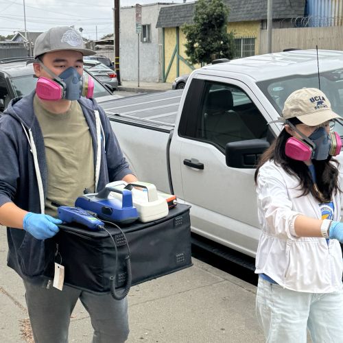
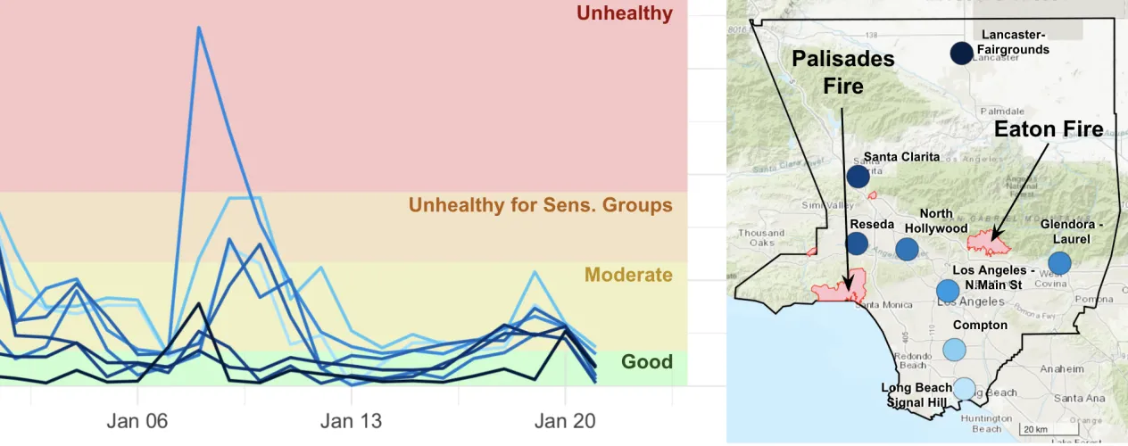
The study of the January 2025 fires in Los Angeles County analyzed the air quality data from federal monitoring stations, low-cost sensors, and satellites, and found that each data source has its advantages and disadvantages: the monitoring stations yielded highly accurate data, but are limited in number; the low-cost sensors are less accurate but more prolific; and the satellite imagery covers larger areas, but do not always reflect the conditions on the ground.
“Timely and accurate air quality information is crucial for the public to reduce their smoke exposure during wildfire events,” said Dr. Claire Schollaert, the study’s lead author and a UCLA Fielding postdoctoral research scientist. “Combining federal monitors, low-cost sensors, and satellite data can provide a more complete picture of local air quality, which can help people make safer choices in real time.”
The January blazes in Los Angeles County, in both the Pacific Palisades-Malibu area in western Los Angeles, adjacent to the Santa Monica Mountains, and the Altadena-Pasadena communities in the foothills of the San Gabriel Mountains, claimed at least 31 lives and damaged or destroyed more than 18,000 structures, according to County estimates.
The researchers also conducted a retrospective study of 2018 fires in California. They found that the ten largest fires in the 2018 wildfire season accounted for nearly all fire-derived PM2.5 pollution that was detected, said Marlier, corresponding author for that study. The team used atmospheric modeling to simulate wildfire contributions to PM2.5 with satellite-based wildfire emissions inventories.
“The largest 2018 wildfires were responsible for the vast majority of downwind fire-derived PM2.5 concentrations in the locations that we examined in California,” Marlier said. “Our analysis allowed us to understand how wildfires burning at different levels of severity impact PM2.5 exposure.”
The pair of 2025 peer-reviewed studies, conducted by researchers from across the University of California and additional collaborators, demonstrate the real-world impact of research led by UCLA scholars, especially as wildfire season in California and western North America continues to lengthen, experts said.
“During and after wildfires, people want to know whether it’s safe to go outside or take their kid to school or the playground,” said Dr. Lara Cushing, associate professor in the UCLA Fielding Department of Environmental Health Sciences. “We can’t currently answer those questions thoroughly because existing air quality monitoring networks do not measure all pollutants of concern – including heavy metals and air toxics that are released when buildings and cars are burned in urban wildfires – and we lack data about the persistence of pollutants in indoor spaces that were exposed to smoke and ash.”
Funding
The June, ACS ES&T Air study was supported by the National Science Foundation Graduate Research Fellowship Program, the California Air Resources Board (CARB) under award number 21RD005, and the University of California Multicampus Research Program and Initiatives (MRPI, MRP-17-446315). Federal and state funding in all cases came through competitive evaluation processes.
The July, ACS ES&T Letters study received funding from the Gordon and Betty Moore Foundation under grant # 11974, which supports the Western Fire and Forest Resilience Collaborative, a program of Cary Institute of Ecosystem Studies led by Cary forest ecologist Dr. Winslow Hansen. Guided by decision makers, the collaborative conducts research to inform solutions to the Western U.S. fire crisis. This study also received funding from the Climate and Wildfire Research Initiative at UCLA. The funders had no role in the conduct of the studies or in the decision to publish study findings.